
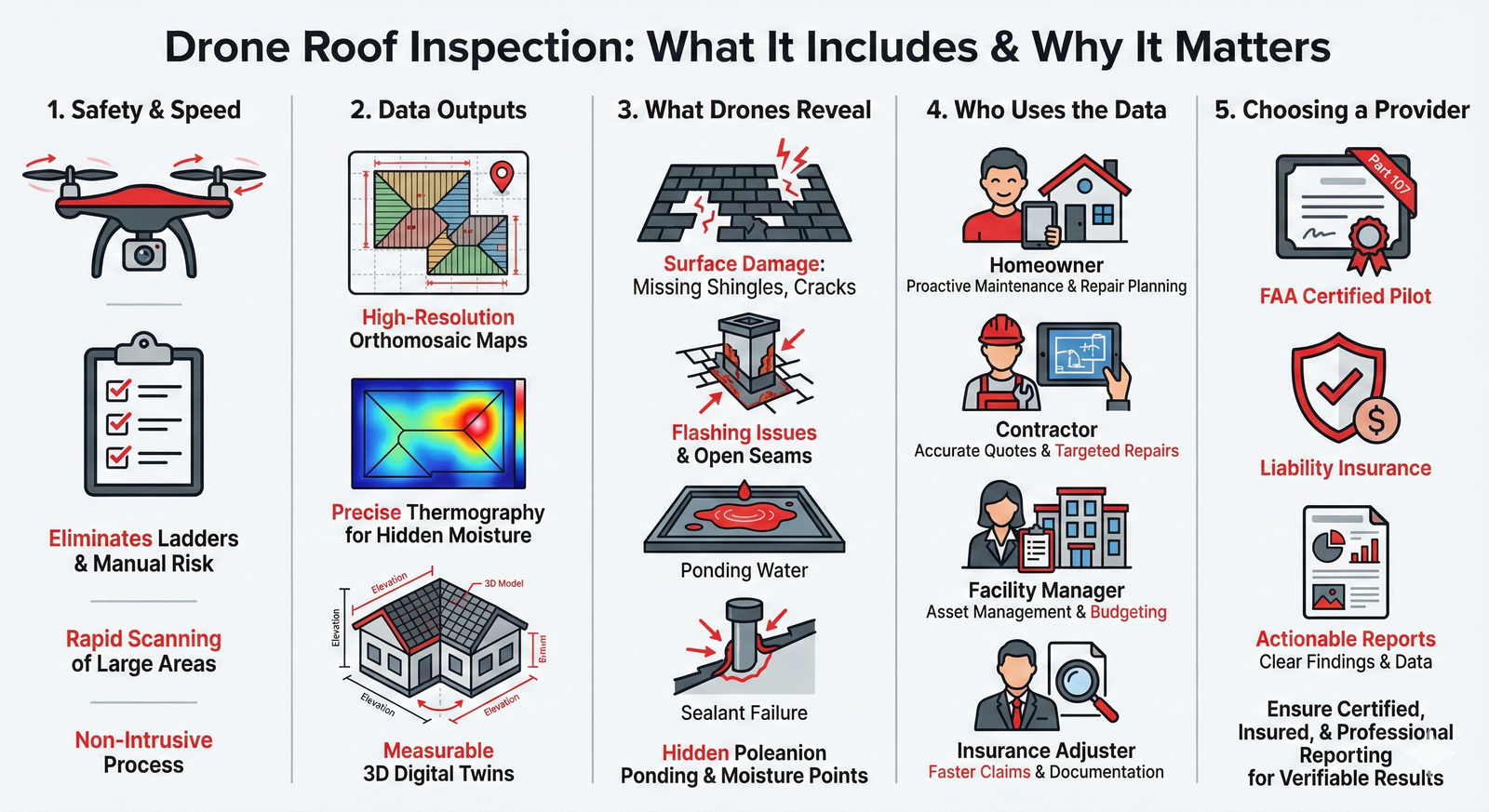
For many years, traditional roof assessment has relied on ladders, harnesses, and manual inspection, an inherently high-risk and time-intensive process. Today, Unmanned Aircraft Systems (UAS), commonly known as drones, have transitioned from novelty tools to essential assets, transforming how property assessments, maintenance planning, and insurance claims are handled.
A construction technology survey, supported by the National Roofing Contractors Association (NRCA), indicated that over half of firms surveyed were utilizing this technology, reflecting a major shift toward preliminary aerial data. This evolution is driven by the need for safer, more efficient work that provides orthomosaic mapping, high-resolution documentation, and proactive risk reduction across the roofing lifecycle.
That momentum has only accelerated as contractors look for ways to verify conditions with verifiable data and models, and to respond quickly and safely after major weather events. In the pages that follow, we will unpack what a drone roof inspection actually delivers, where it outperforms manual methods, how certified FAA Part 107 pilots capture thermal and visual evidence, and how owners, insurers, and facility managers are using the results for smarter maintenance and targeted repairs.
What a Drone Roof Inspection Really Is
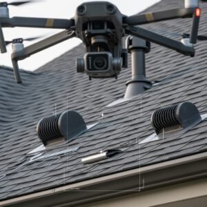
A drone roofing inspection uses a small aircraft equipped with a high-resolution camera (typically 20MP or higher) to look closely at every part of your roof. The UAS captures clear photos and video that show the surface, edges, and hard-to-reach areas. This method is inherently safer and significantly faster than sending people up ladders, and it provides a more objective, comprehensive picture of the entire roof surface.
With this method, the pilot can spot loose shingles, cracks, open seams, or places where water might be infiltrating. Some specialized roof inspection drones carry thermal cameras that highlight hidden issues. On larger commercial jobs, the captured images are processed using data processing software (like Pix4D or DroneDeploy) to create a geo-referenced, measurable 3D model that helps everyone understand slopes, valleys, and flashing details.
Speed and Coverage: Traditional vs. Drone Inspection
Old-style inspections take significant time. Personnel climb up, move ladders, and reset safety lines repeatedly to reach each section, consuming valuable man-hours. A drone roofing inspection completes the same comprehensive check in a short, predefined flight window.
| Traditional Manual Inspection | Drone Roof Inspection |
|---|---|
| High Risk: Requires ladders, harnesses, and safety lines. | Safe: Pilot remains on the ground; zero roof foot traffic. |
| Slow: Requires moving gear to reach each section (Hours/Days). | Fast: Comprehensive check in a short flight window (Minutes/Hours). |
| Subjective: Relies on the inspector’s notes and selective photos. | Objective: Provides total coverage, 3D models, and repeatable data. |
Rapid Post-Storm Damage Assessment
The drone follows a Standard Operating Procedure (SOP) flight plan that ensures coverage of the entire roof. After a storm or repair, the pilot can fly the exact same path again and compare new images with the older, baseline data. This comparison allows for side-by-side analysis of minor changes across months and seasons. For a commercial property with multiple buildings, the time savings are massive. What once took days can often be scanned and documented in a single morning, clearly identifying which roofs need urgent tarping and which are fine.
What Roof Inspection Drones Reveal Beyond the Naked Eye
High-resolution photos allow for zooming in to find details that are impossible to spot from the ground. You can detect misaligned shingle rows, nails lifting under tabs, hairline cracks in brittle flashing, and sealant that has started to pull away at vents and skylights. That level of detail is hard to match without walking every linear foot of the roof.
High-Fidelity Thermography
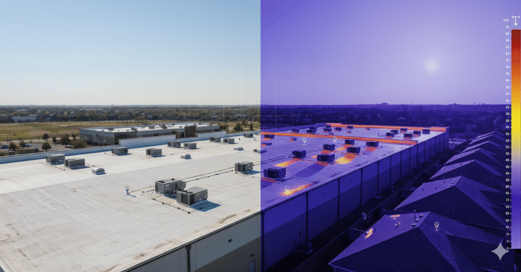
High-Fidelity Thermography (Infrared Imaging) adds a second, critical data layer. Best executed at dawn or dusk (low solar load), the resulting IR maps reveal temperature differentials caused by Solar-Loaded Moisture (SLM). These warmer spots often correspond with trapped moisture within the insulation or membrane layers. While thermography is diagnostic—it does not confirm a leak—it is an essential tool for creating a moisture-entry hypothesis. It pinpoints the exact zones for core sampling or electronic moisture meter testing, greatly reducing the need for destructive, exploratory cuts and enhancing the overall asset digitization process.
Turning Drone Roof Surveys into Actionable Roofing Reports
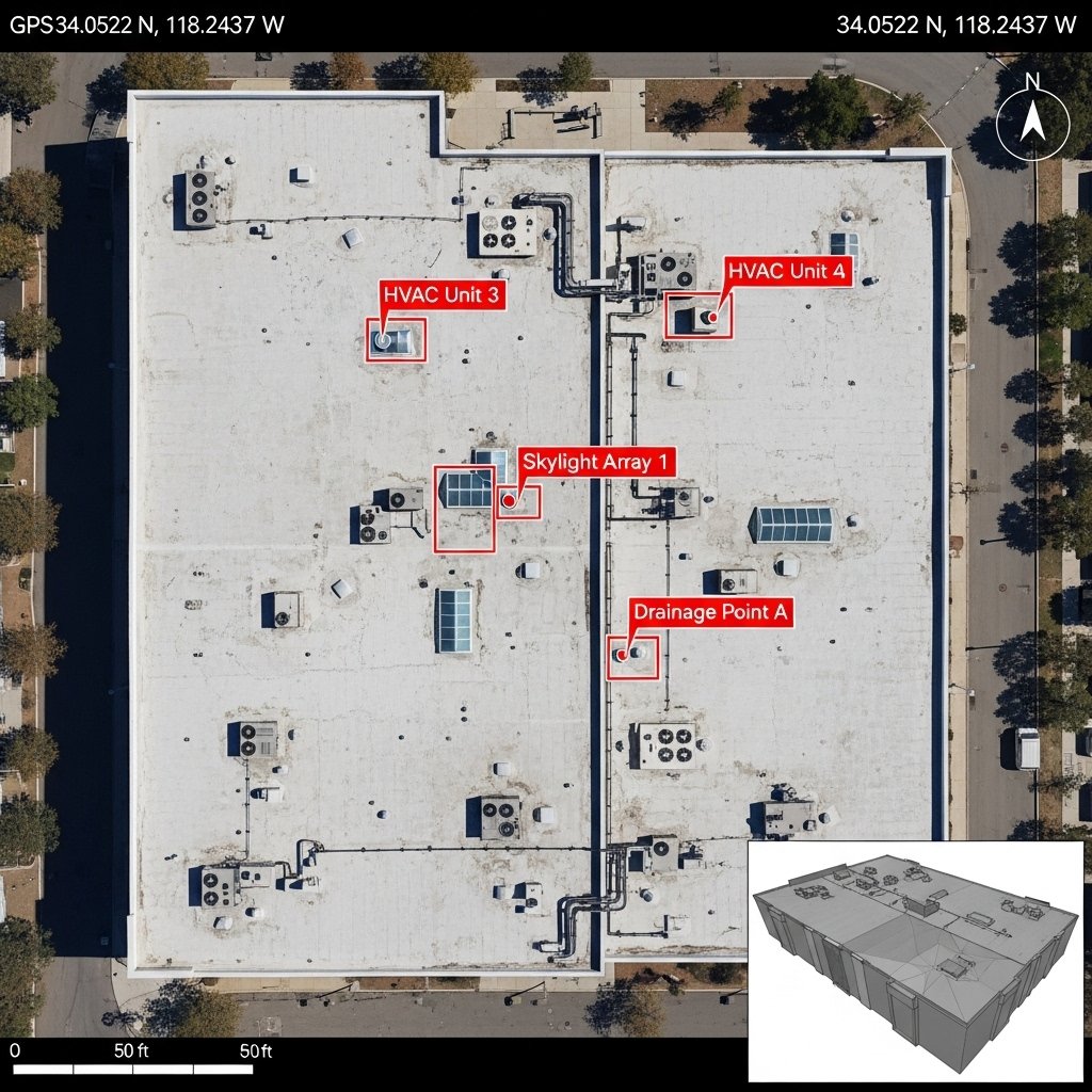
A strong report from a drone roof survey does more than show pictures. It proves full coverage with a top-down orthomosaic map that you can measure with pinpoint accuracy. It links close-up photos to exact GPS locations on that map. It also sorts findings into simple action levels: watch, repair soon, and fix now. That structure helps owners plan budget and schedule proactively.
Real World Scenario: ROI in Action
For instance, on a recent 200,000 sq ft warehouse inspection, the orthomosaic map accurately measured 15 areas of ponding water—findings which were then linked via GPS coordinates to a 3D model. This specific data processing software output allowed the facility manager to budget for three targeted repairs (totalling $12,000) instead of a full tear-off quoted at $150,000, illustrating the true ROI of asset digitization.
On commercial roofs, the report often includes a basic 3D view so parapets, curbs, and HVAC units are easy to contextualize. On residential properties, a clear photo set with concise notes is often preferred. This focus highlights what truly matters and gives the owner the confidence to move forward.
When a Drone Roof Survey Outperforms a Ladder
Some roof situations are simply safer and better checked by air first. Consider:
- Hazardous Surfaces: Metal panels that become slick with morning dew, or older buildings where the deck may be structurally compromised.
- Post-Storm Conditions: Areas where streets and roofs can be covered with nails, debris, or compromised materials.
- High and Flat Roofs: Large, low-slope roofs where ponding and seam issues can hide across a vast surface. What would take hours to walk can be scanned and mapped in minutes.
In these cases, a drone roof survey provides a safe first look without waiting for lifts or exposing personnel to weak surfaces, allowing you to flag points for targeted on-foot inspection.
Drone Roofing Inspection for Insurance and Documentation Accuracy
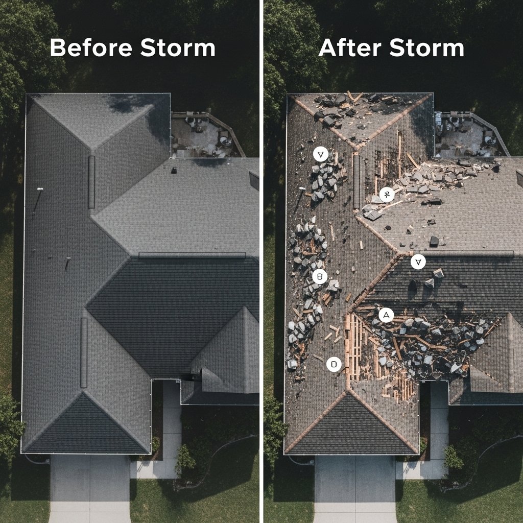
Disputes are often about proof, and clear, objective documentation bridges the gap. Images that are date-marked and geo-location tagged establish the condition of the roof: prior to a storm, the pattern of damage (like hail or wind uplift) after the event, and the quality of repairs involving flashing and seams. Thermal pictures and notes also make it significantly easier to come to an agreement regarding the scope and costs of restoration.
Routine drone inspections before storm season create a visual baseline. When the same flight path is repeated after bad weather, you get a true side-by-side comparison that shows exactly what changed. This verifiable record helps:
- Speed up insurance claims.
- Reduce repeat site visits by adjusters.
- Gives both property owners and adjusters solid proof of damage or repair quality.
How To Choose Drone Roof Inspection Services
The lowest quote is not a win if the report leaves you guessing. Selecting the right service is about professionalism, transparency, and data quality.
1. Verify Credentials and Insurance: Ask the provider to share current pilot certificates (FAA Part 107 in the US, or equivalent international licensing). Confirm they carry robust Public Liability Insurance for drone operations. Review recent flight logs and proof of regular equipment maintenance.
2. Evaluate Deliverables: Review two or three full sample reports from actual jobs (commercial and residential). Ensure the team understands both roof system types and can explain complex results in clear, actionable language.
3. Define the Scope: Set the scope before anyone flies. Decide what you need: a close photo set for a small repair, a full stitched orthomosaic map for measurements, a thermography pass to look for hidden moisture, or a simple 3D view for planning.
4. Data Retention: Ask the provider to keep the original raw images and video in addition to the final report so you can return to the data later for warranty reviews or future insurance claims.
Final Thought: Choosing a Professional Partner
Roof decisions are easier when you can see the whole story with verifiable, high-fidelity data. A well-run drone survey provides safe access, fast coverage, and sharp detail that turns images into a plan you can act on.
When selecting a service provider, remember that the quality of the report depends on more than just the camera. Look for a team whose pilots hold FAA Part 107 Certification and carry robust Public Liability Insurance. A professional partner should blend the efficiency of a UAS survey with the precision of skilled, follow-up on-roof checks, ensuring the results are explained using clear, actionable terminology. By prioritizing expertise and verifiable credentials, you turn a set of images into an invaluable planning tool for longer roof life and better asset management.
Are you ready to start?
Get a comprehensive aerial assessment for your property today with verified data.
